
The analysis on this page comes from iVerify, North Star Group’s patent-pending site-screening and origination program, which converts corridor, freight, parcel, flood, soil, and logistics data into developer-grade site packets. The full screen behind it is the iVerify site report for this node.
Current stage
North Star Group · iVerify · pre-validation screening
What this screen examines
This is a worked example at the I-95 × US-278 node in Hardeeville. On a ~20-acre site, a controlled truck-and-trailer yard prices at roughly $12-$15/night; at ~70% occupancy that is about $386K-$483K of stabilized NOI. On the drier, well-selected ground it holds a 12-16% yield on cost that clears a 12% return floor on the yard alone; the wet-clay end of the cost band is where the surface section erodes it, so the parcel has to sit on the Zone X terraces. The first move is validating the market; once the parcel is controlled, the held land earns as trailer/IOS parking until a buyer commits.
Deal economics at a glance
Exits
The yard is built owner-direct and stabilized as a controlled truck-and-trailer operation. Once it cash-flows, there are three ways to exit, and the market picks the best one at the time:
| Exit | What you sell | Why it works |
|---|---|---|
| 1. Sell the whole asset | The entire stabilized parking-and-storage operation as a single income property | A fully-leased IOS asset is what an institutional or 1031 buyer wants; cleanest story, and as one asset it can price a little stronger |
| 2. Carve the entrance pads | The ~5 acres at the lot’s entrance to a fuel/retail/service operator, parking sold separately | The full lot has captured the customers; an operator pays a pad premium for access to that captive traffic, on top of the yard’s income value |
| 3. Develop and sell the best use (conditional) | On a parcel that clears the development screen, North Star develops the highest and best building itself, a logistics or industrial build to suit, a service or retail building, or a travel-center format, leased to a creditworthy tenant on a triple net basis and sold as a stabilized asset | North Star develops it, signs a creditworthy triple-net tenant, and sells the stabilized asset; a credit net lease sells at a lower cap rate than the yard, so the value is higher, and that spread sits outside the gain figure below |
Illustrative planning figures from the validation model, not a projection of return. Values rest on achieving the rate and occupancy below and on the surface-section cost the soils drive; the exit cap is the market’s call. A point estimate would be false precision; the output is a range.
The revenue engine is the same as any yard of this size; what moves the gain at this node is the cost side, because the coastal-plain soils run wet and clay-heavy. At a $12-$15/night band and ~70% occupancy, the yard clears a 12% return floor on the drier, well-selected ground, and the table below reads against the mid of the cost band:
| Rate | Stabilized NOI | Yield on cost | 12% floor | Yard gain @ 9% cap |
|---|---|---|---|---|
| $12 / night (floor) | ~$386K | ~11.7% | at the line | ~$0.8M |
| $14 / night (mid) | ~$451K | ~13.7% | clears | ~$1.5M |
| $15 / night (top) | ~$483K | ~14.6% | clears | ~$1.85M |
Revenue math (base $14/night): 180 spaces × $14/night × 365 nights × 70% occupancy = ~$644K gross; less 30% operating expense = ~$451K NOI. Yield read against the ~$3.3M mid of the cost band. Sale values are net of a 4% cost of sale.
The demand bar is moderate, but the cushion is thinner here than on dry ground because the surface section costs more. At the $14 mid-case the yard clears the 12% floor at ~62% occupancy against the mid cost band; on the lower-cost drier parcels that threshold falls, and on the wet-clay high-cost end it rises. So the ~70% assumption carries cushion on the right parcel, subject to validating actual demand, surface cost and soils, access, flood set-back, and operating expense. And while the entrance pads wait for an operator, they run as trailer/IOS parking: the held land earns, it does not just carry.
| Metric | Figure | Read |
|---|---|---|
| Direct total development cost (yard incl. land) | ~$3.0-3.6M | Owner-direct, preferred path; band reflects the wet-clay surface section and detention |
| GC retail cost | ~$5.3-5.9M | Stress / reference case; weakens economics |
| Stabilized NOI ($12-$15/night, 70% occ) | ~$386-483K | Controlled yard only |
| Yield on cost | ~12-16% | Clears the 12% floor on the drier, lower-cost ground; thins toward the floor on the wet-clay end |
| Yard income value @ 9% cap | ~$4.1-5.2M | Exit 1, NOI ÷ 9% (~$4.3-5.4M) less 4% cost of sale |
| Yard sale gain | ~$0.8-2.1M | Value less ~$3.0-3.6M cost |
| Entrance pad (5 ac) | ~$0.5M gain | Exit 2, ~$0.6M value less ~$0.15M basis |
| Gross gain after stabilization | ~$1.3-2.6M | Yard + entrance pad, before carry |
Exits 1 and 2 are income-based; they are what the gain figure above rests on. The third is a development North Star runs itself, and it pencils the way any ground-up development does, on the whole screen: location, access, visibility, economics, demographics, competition, and site conditions. The node already carries much of it: a primary I-95 corridor location carrying 58,100 vehicles/day, a working Hardeeville logistics submarket minutes from the Port of Savannah, and an existing Pilot Travel Center at Exit 5. Where a parcel here also clears the acreage of dry, buildable ground and the rest of that screen, North Star develops the best use on it, a logistics or industrial build to suit, a service or retail building, or a travel-center format, and signs a creditworthy tenant to a triple net lease. A credit net lease sells at a lower cap rate than the yard's conservative 9%, so the stabilized asset is worth more, and North Star, the merchant developer, realizes that spread at sale, so this sits as upside rather than in the gross-gain range above. The format sets the buildable acreage: a full travel-center wants about 25 acres and will take about 20, a build to suit runs to the tenant box, so the broker target is a dry-ground site or assemblage sized to the format, which also enlarges the yard economics beyond the ~20-acre example modeled here.
Known validation items
These are diligence items, not unknowns being glossed; each is a normal validation step behind site control, before material spend. At this node the top two are soils/surface cost and flood set-back:
| Item | Why it matters |
|---|---|
| Surface section & geotech (soils) | The single highest-leverage cost item: wet, clay-heavy, poorly-drained coastal-plain soils drive undercut, stabilization, base design, and detention; this is what moves the gross gain |
| Flood zone / buildable footprint | ~23% of the sampled box is in the FEMA special flood hazard area; the buildable acreage sits on the Zone X terraces, read tract by tract with base flood elevation |
| Access / driveway approval | Truck-yard viability depends on ingress/egress and SCDOT encroachment coordination on I-95 / US-278 |
| Zoning / permitted use | Hardeeville and Jasper County classifications govern whether yard, IOS, fuel, and service uses are by-right or need a rezoning/variance |
| Turning geometry on the selected parcel | A long-narrow parcel can lose usable acreage to circulation; shape drives the stall count |
| Water / sewer / septic | Relevant once restroom, repair, or operator/fuel use is in play |
| Operator interest | The operator-exit case strengthens materially with 3-5 real operator calls or LOI targets |
| Demand (rate × occupancy) | Confirm the ~$12-$15/night at ~70% band holds on this I-95 segment |
Order of work
Market first
The screen comes first, before any spend on site control, diligence, or construction. Does the Hardeeville I-95 × US-278 interchange support a paid truck-parking, IOS, and operator-pad use at all? If it holds, the next step is choosing a parcel and an ownership path, then sizing a control-and-diligence budget to that parcel. The worked example here uses the drier-ground parcel near the interchange. Control is funded once the node, the parcel, and the terms line up.
| Step | Decision |
|---|---|
| 1 | Confirm the market screen: node demand, rate, occupancy, and operator interest support a paid truck-parking / IOS / operator-pad use. |
| 2 | Select the preferred parcel and ownership path; size the site-control and diligence budget around that parcel. |
| 3 | Secure property control: option, purchase contract with due-diligence period, ground lease, or phased takedown. |
| 4 | Confirm civil / geotech scope and validate site layout once a control path is realistic. |
| 5 | Update budget and proforma; decide whether to exercise, assign, ground lease, JV, or hold for operator pad. |
| 6 | Bring in construction capital only after market, site control, and validation survive. |
Representative conceptual site plan
Site layout

| Zone | Acres | Function |
|---|---|---|
| Entrance operator pad | ~5.0 | The corner at the lot entrance, sold or ground-leased to a fuel, convenience, truck-service, repair, or retail operator who wants the captive traffic (Exit 2) |
| Controlled truck-and-trailer yard | ~10.0 | Initial use: truck parking, trailer drop / IOS staging, fleet parking, detention, and demand generation |
| Support / utility / detention | ~4.94 | Utilities, generator, restroom/septic, and stormwater detention, larger here than on dry ground because the coastal-plain soils shed water; usable functional land, not a separate sale |
On a ~20-acre buildable site, the ground is treated as a phased truck-service platform. The corner at the lot entrance is reserved for the operator pad. The rest runs as the controlled truck-and-trailer yard. Stormwater detention is folded into the plan and carries more weight here than on dry ground, and the support land stays usable as IOS and overflow rather than sitting idle. Acreage and layout vary by the parcel chosen and by how much of it clears the flood zones.
Profit Model
Build cost
At the I-95 × US-278 node, the site runs two ways. The first is a truck-and-trailer yard, the simplest use to validate: it cash-flows on its own, proves the demand any larger use rests on, and carries its own income exits. The second is the parcel best use, developed by North Star and sold as a stabilized asset leased to a creditworthy triple-net tenant: on a parcel that clears the full feasibility screen, the sponsor builds the highest and best use, a logistics or industrial build to suit, a service or retail building, or a travel-center format, and leases it to a credit tenant rather than selling the ground to an operator. That path is a reasonable prospect at this node, not a stretch: a Pilot already operates here as an established truck-stop anchor, on a primary corridor minutes from the Port of Savannah logistics submarket. What it asks for is a parcel here that clears the development screen (the full feasibility set, including dry, buildable ground) plus the buildable acreage the chosen format needs: an acquisition target the broker works to, not a feature of a site in hand. The yard path stands on its own; the developed lease is the higher one, where a fitting parcel turns up. Which is highest-and-best is a validation question, not a claim the page makes.
The cost side is where this node differs from a dry-ground site. The coastal-plain soils run wet and clay-heavy, so the surface section, subgrade treatment, and stormwater detention carry more cost, and the buildable footprint is set by the flood zones. That is why the direct development cost is carried as a band, ~$3.0-3.6M, not a single figure: where a parcel lands in that band is a soils-and-flood question the geotech answers.
These cases assume a control path on the parcel is in hand or in reach; the spending that confirms them is staged behind site control (see Market first, then site control).
| Case | Purpose |
|---|---|
| Initial yard-only case | Tests whether controlled parking / staging can carry the initial project on the drier ground |
| Seeded operator-pad case | Tests whether the yard increases the value and attractiveness of the entrance pad |
The budget model compares two delivery paths: conventional GC retail and owner-direct procurement with construction management. Direct procurement assumes the sponsor buys major components directly where practical: aggregate/base, geogrid, fencing, lighting, gate systems, generator, restroom/septic service, security, and site components. The purpose is to show whether the project remains inside the required NOI-to-cost screen after real civil, soils, and operating costs are validated.
The model runs the same two delivery paths, owner-direct and GC retail. Owner-direct procurement reduces modeled development cost by roughly 40-45%, about $2.0M, versus the GC-retail stress case. The return and exit figures are in Deal Economics above; the dashboard below shows the build. Illustrative planning figures from the validation model; not a projection of return.

Entrance pad
Exit values
Under Exit 2, the ~5 acres at the lot’s own entrance sell separately as an operator pad. A full yard puts a steady crowd of paying drivers at the entrance: fuel, food, and service demand an operator can reach from the corner. Until a buyer commits, the pad runs as trailer drop and IOS staging, so the held land earns. The remaining support land is functional: utilities, detention, and IOS overflow folded into the operation.
| Scenario | Meaning |
|---|---|
| Low, bulk-land credit | Conservative case: value the pad as raw land only |
| Mid, operator pad | The busy lot has captured the customers; an operator pays for access to them |
| High, develop and sell | Where a parcel at this node clears the development screen on dry, buildable ground, North Star develops the best use, leases it to a creditworthy triple-net tenant, and sells the stabilized asset at a lower cap |

Development thesis
An existing node
Hardeeville is an existing I-95 truck-service node inside a working, port-driven logistics submarket, with an established stop economy at the interchange.
The Pilot Travel Center at Exit 5 and the fuel stop at Exit 8 show that drivers already stop here. I-95 and US-278 carry the corridor traffic, and the Port of Savannah sits minutes south. The warehouse submarket around the port loads, stages, and distributes that freight. It includes a Home Depot distribution center, food and 3PL warehouses in the Riverport corridor, and the Clarius Park spec-industrial campus now leasing. Hardeeville can serve as the lower-friction overnight and staging point on the interstate for that trade.

Demand evidence
Corridor and freight base
The demand case here rests on corridor volume and the freight generators around it. Two of the three legs are strong and documented; the third, the nightly rate and a metered occupancy figure, is the item still to confirm. The driver-reported fill below shows the existing yards already run full overnight, short of a metered study.
| # | Fact | Source |
|---|---|---|
| 1 | Corridor volume. I-95 at this interchange carries 58,100 vehicles/day and US-278 carries 27,000. I-95 is a primary East Coast freight corridor; US-278 feeds toward Bluffton, Hilton Head, and US-17 to Savannah. The count is all vehicles, not truck share, and parking demand turns on truck volume, so the truck-specific share is a validation item. | SCDOT traffic counts |
| 2 | The freight base is here. The site sits minutes from the Port of Savannah trade and inside a working Hardeeville logistics submarket: a Home Depot distribution center, food and 3PL warehouses in the Riverport corridor, and the Clarius Park spec-industrial campus now leasing. That base generates the trailer moves, drops, and overnight staging a secured yard serves. | iVerify logistics-facility layer |
| 3 | An established stop economy at the node. A Pilot Travel Center anchors Exit 5 (fuel, showers, truck parking) with a second fuel stop at Exit 8. Drivers already stop at this interchange; the existing Pilot is the proof the node works, and a reservable, storage-capable yard is a different product than a free first-come lot. | iVerify truck-stop layer |
| 4 | The existing yards run full overnight. On Trucker Path, the Pilot at Exit 5 (109 truck spots) and the QuikTrip at Whyte Hardee Blvd (10 spots) both reported Full on their most recent driver updates and are predicted Usually Full overnight; a second Pilot on the corridor read the same. The Pilot’s same-day log (Tue, Jun 30) moved from Many Spots mid-morning through its Paid Only tier to Full from mid-afternoon straight past 10:40pm, and it stayed Full the prior evening: the overnight, hours-of-service-driven peak a reservable yard is built for. | Trucker Path driver reports + parking history (Jun 29-30, 2026) |
Observed overnight fill, Trucker Path, Jun 29-30 2026


Corridor context

Driver behavior favors this kind of site. A Class 8 driver near an hours-of-service limit will not thread a 70-foot rig through city streets; the preference is to pull off the interstate, park, and roll. That favors an interstate-adjacent yard at this node over in-town lots.
The capture needed is small. A ~180-space yard needs about 126 paid trucks a night (70% occupancy) to clear its return floor, a small share of 58,100 vehicles/day on I-95, next to a port-driven logistics submarket.
Where this still needs work: the fill data above is crowd-sourced driver reporting, not a metered study: the screen still carries no metered overnight-occupancy count, no truck-specific share of the 58,100-vehicle/day count, and no live in-corridor rate comps for this I-95 segment, and the Jason’s Law / SCDOT truck-parking need layer returns no state need-point within regional range. The $12-$15/night band is carried from the model as an assumption to test, not a corridor comp. A metered occupancy and rate study on the existing yards is the remaining demand step before site control; the observed overnight fill is the evidence pointing to it.
For illustration
Example parcel
The read below is how the iVerify screen reads one actual candidate at this node, a ~28.5-acre parcel near the interchange. It is here to illustrate the method, not because a parcel is listed, available, or selected. The screen holds 1,742 parcels; 101 are 10 acres or larger. The large holdings are timber and hunting ground (Okeetee Club at ~15,219 acres, and several 1,000-2,600-acre tracts), carried at low agricultural use-valuations rather than market. The candidates for a frontage yard are the smaller 10-to-30-acre parcels nearest the interchange, on the drier Zone X terraces and outside the AE/A/AH flood zones.
| What the screen reads | On this candidate |
|---|---|
| Size | ~28.5 acres |
| Distance to interchange | ~2.0 mi |
| Flood | Outside the flood zones, 100% Zone X, 0% regulatory floodway, 0% AE / 0% AH |
| Soils | 39.9% hydric; dominant Wahee (60%) and Bladen (39.9%), the wet-clay associations, not the drier minority |
| Relief | 16.5-21.6 ft elevation (5.1 ft across the parcel), flat coastal-plain ground |
| Shape | ~1,018 × 2,038 ft (5,399 ft perimeter) |
| Assessed (ROM) | ~$670 appraisal-district value, a low agricultural use-valuation, not a market price |
| To be verified | Buildable footprint, base flood elevation, surface section / geotech, road access, utilities, zoning, ownership terms |

This candidate reads the way the node's ground tends to. A parcel clears the flood screen (Zone X, outside the AE/A/AH zones) and still sits on the wet-clay soils (Wahee, Bladen) that carry the surface-section cost. Where a parcel lands in the ~$3.0-3.6M cost band is that soils question, and the geotech answers it. No parcel is presented here as fully engineered or as available. The next work is normal validation on a specific candidate: geotech and surface-section ROM, flood set-back and base flood elevation, zoning, owner terms, access/driveway confirmation, utility confirmation, and operator/rate validation.
Soils and grading
Fill and stabilize
The engineering question here is the subgrade: whether a given tract carries enough dry, well-drained ground, and what surface section the wet, clay-heavy coastal-plain soils demand under a truck-yard load.
| Soil association | Box share | Plain-English read |
|---|---|---|
| Argent-Okeetee | ~25% (largest) | Clay-throughout, poorly to very-poorly drained, high water table; heavy runoff / low infiltration, validate undercut, stabilization, and detention |
| Bladen / Santee / Wahee | much of the rest | Poorly-drained clay units, several rated hydric, ties to the flood zones; the wet ground to route around |
| Eulonia / Coosaw sand / borrow-pit | the drier minority | Better-drained ground, the target for a buildable yard; where the surface-section cost is lowest |
The survey is broad-scale and does not fix the buildable acreage on any one tract; the dry, better-drained ground is the minority, so parcel selection onto it is the load-bearing move. What flat coastal-plain ground gives back is grade: it does not read as a cut/fill or blasting problem; it reads as a subgrade and drainage problem.
Validation tests
| Test | Purpose |
|---|---|
| Test pits / borings | Confirm actual soil, clay depth, water table, and buildable footprint |
| Proctor density | Confirm compaction behavior on clay subgrade |
| Plasticity index | Identify shrink-swell / pumping risk in the clay |
| R-value or CBR | Support pavement / aggregate-base design over soft subgrade |
| Seasonal high water table | Confirm depth to water, drives fill height, underdrain, and detention |
| Wetland / hydric delineation | Separate buildable ground from jurisdictional / hydric areas |
| Cut/fill & import estimate | Confirm fill needed to raise the pad above the wet ground |
| Surface-section ROM | Compare geogrid/geotextile + aggregate base, cement/lime stabilization, millings, or asphalt-at-throat sections |
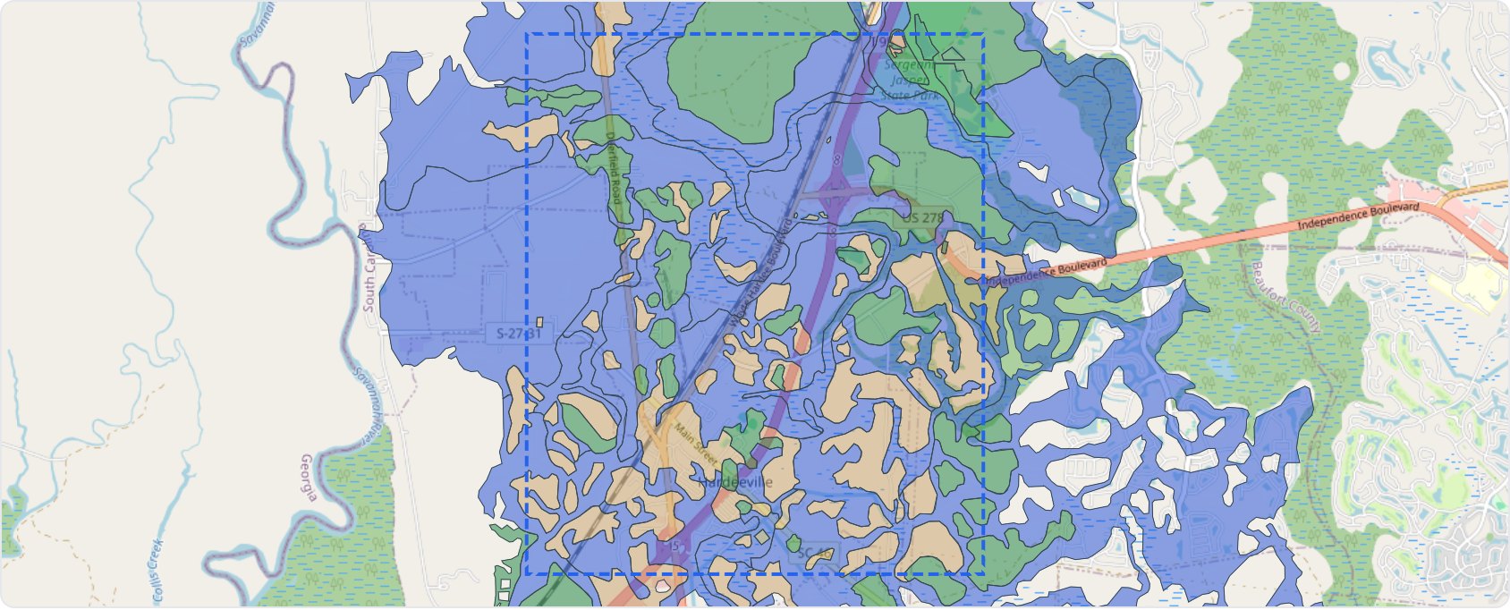
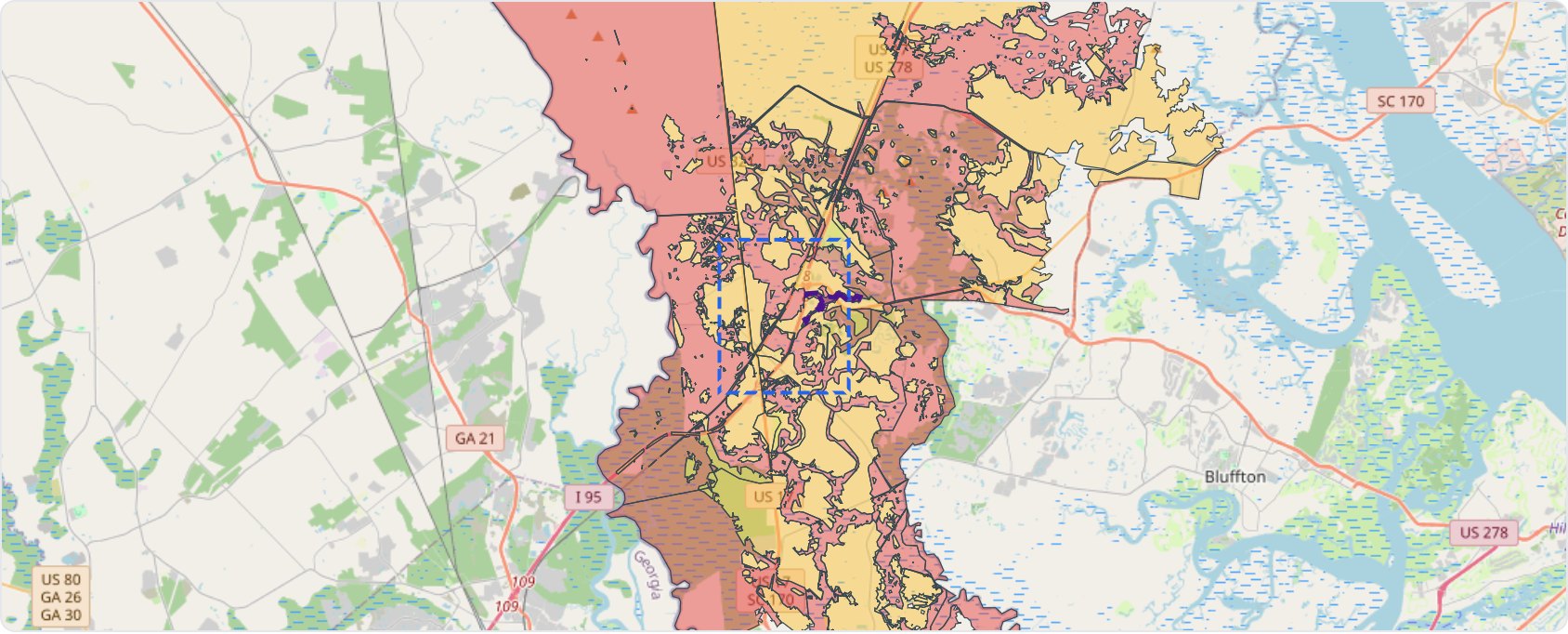
The validation package converts the wet-clay subgrade and the flood set-back into geotech, civil ROM, and local contractor pricing: the numbers that decide where in the ~$3.0-3.6M cost band a given parcel lands.
Phase 2 · site control + diligence
Control, then diligence
This is Phase 2 work. After the market screen survives and a preferred parcel and ownership path are identified, validation spending follows an acceptable option / PSA / ground-lease path. Once the site can be tied up, this budget buys the evidence needed before construction equity is exposed.
| Item | Purpose |
|---|---|
| Developer site sketch | Establish phased site logic |
| Civil ROM | Grade, drainage, entrance, detention, and the wet-clay surface section |
| Geotech allowance | Confirm clay subgrade performance, water table, and base design |
| Rate comps | Validate the $12-$15/night rate band against local demand |
| Operator calls | Test yard, fleet, trailer, IOS, fuel, and service demand |
| Zoning confirmation | Confirm permitted-use path |
| Owner contact | Option, PSA, ground lease, phased takedown, or pad structure |
| Utility check | Power, water, septic/restroom service, generator, lighting, telecom |
| Updated proforma | Confirm whether the project still clears the return screen |
The candidate advances only if site control, validation, and economics all remain inside the screen.
Powered by iVerify Patent Pending
The source data
The screen behind this page is the live iVerify report for this node. iVerify pulls the public data and the table shows what each layer becomes in it.
| Raw data | iVerify output |
|---|---|
| Traffic counts (SCDOT) | Corridor demand signal |
| FMCSA carrier records | Local carrier / trailer / power-unit demand |
| Public truck-parking inventory | Supply constraint signal |
| Parcels | Owner / size / value / geometry review |
| FEMA flood | Buildable-footprint screen |
| NRCS soils | Soil / grading / surface-section risk screen |
| Elevation | Relief and civil-cost signal |
| Lodging / truck services | Overnight-stop and service-node signal |
| Logistics / warehouse layers | Port-of-Savannah submarket context |
| Broker tool | Parcel shortlist and action list |
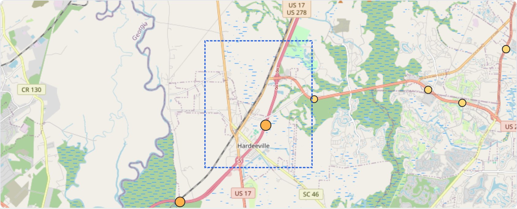
The page shows the outputs: report, parcel facts, method. The raw tables, carrier exports, scoring weights, schema, and extraction logic stay inside the engine.
Backup Documents
Backup, on request
iVerify Report 16
Full technical screen: traffic, parcels, flood, soils, topo, carriers, lodging, truck-service context, broker tools.
Excel Validation Model
Direct procurement vs. GC retail, the wet-clay cost band, yard economics, and the gross-gain build.
Opportunity Brief
Two-page executive summary, current model and demand context. Available on request.
Conceptual Master Site Plan
Phased plan with entrance operator pad, controlled yard, and support / detention reserve. Available on request.
North Star Group / iVerify
Developer-led method
North Star Group is a developer-led systems and real estate platform focused on practical site origination, development strategy, infrastructure, and applied AI tools. iVerify is North Star’s corridor-screening and parcel-origination system for freight, IOS, truck-service, and logistics-land opportunities.
Michael Hoffman is the principal of North Star Group, Inc. His background includes real estate development, systems integration, and invention work, with issued patents and pending housing / site-screening concepts. The Hardeeville package reflects a developer-led method: screen the corridor, isolate candidate parcels on the drier, buildable ground, identify the demand signal, prepare a validation budget, and advance only if the economics survive real-world checks.
Contact
Michael Hoffman
North Star Group, Inc.
Fairhope, Alabama
701-770-9118
michaelh@nsgia.com
www.nsgia.com
This is a pre-validation screening package. Construction capital, final site control, final engineering, and final operator structure are not being requested at this stage.